

weatherman
Well-Known Member
Hello,
Not a bad weekend with very little rain around. Details below.
If you need a forecast specifically for your location then you can talk directly to our forecasters 7-days a week, between 8am and 5pm using our WeatherLIVE service. You can call from any telephone in the UK or Ireland. Full details and charges are here https://premium.weatherweb.net/talk-to-a-forecaster-with-weatherlive/
This service is used by farmers, sailors, pilots and just about anyone who needs to know the weather forecast in the coming days and weeks tailored to their plans.
Remember too that Weatherweb Premium also has lots of weather wisdom and is continuing to grow with more sailors joining every week. There's stack of weather information, forecasts and learning to be found on the website and you can try Weatherweb Premium completely free at http://premium.weatherweb.net/become-a-member/
A reminder you can follow my musings on instagram @weatherschooluk
And don't forget youcan also receive these forecasts by email, just send a blank email to
generalweather-subscribe@weatherweb.net
Kind regards,
Simon
WEEKEND WEATHER FORECAST
============================
Issued: 1600hrs, Friday 12th June 2026
SATURDAY
=========
High pressure builds over the south of the British Isles on Saturday. An occluded front moving south through northern Scotland.
Fair with broken cloud across much of Ireland, England and Wales. There is a risk of some low cloud affecting western parts of the English Channel as well as Southern Ireland and southwest England.
The occluded front gives some rain to northern Scotland, this drifting into central areas too. Scattered showers and more cloud for southwest Scotland but drier in the east.
An occasionally spot of rain over the northern Pennines but for most the day stays with broken cloud and some bright or sunny spells.
Winds WNW 25-30kt (F6-F7) northern England and Scotland, easing to mainly W 15-22kt (F5-F6) in southern areas. Some sea breezes may affect southern coasts in the afternoon.
SUNDAY
=======
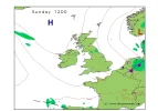
High pressure affecting many areas on Sunday, centred northwest of Scotland. A mainly northerly flow affects the British Isles.
The flow is more unstable in eastern areas and this allows for a few showers here.
Generally more cloud in Ireland, Wales and western England. Whilst it stays dry for most there are likely to be some showers in western Ireland.
Most other parts of England and Wakes tending to see further cloud in the afternoon. The best sunny spells tending to be through Scotland, Northern England and Northern Ireland.
Winds mainly N 12-18kt (F4-F5) but NW 25-30kt (F6-F7) along eastern coasts at first.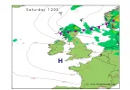
**ends**
Not a bad weekend with very little rain around. Details below.
If you need a forecast specifically for your location then you can talk directly to our forecasters 7-days a week, between 8am and 5pm using our WeatherLIVE service. You can call from any telephone in the UK or Ireland. Full details and charges are here https://premium.weatherweb.net/talk-to-a-forecaster-with-weatherlive/
This service is used by farmers, sailors, pilots and just about anyone who needs to know the weather forecast in the coming days and weeks tailored to their plans.
Remember too that Weatherweb Premium also has lots of weather wisdom and is continuing to grow with more sailors joining every week. There's stack of weather information, forecasts and learning to be found on the website and you can try Weatherweb Premium completely free at http://premium.weatherweb.net/become-a-member/
A reminder you can follow my musings on instagram @weatherschooluk
And don't forget youcan also receive these forecasts by email, just send a blank email to
generalweather-subscribe@weatherweb.net
Kind regards,
Simon
WEEKEND WEATHER FORECAST
============================
Issued: 1600hrs, Friday 12th June 2026
SATURDAY
=========
High pressure builds over the south of the British Isles on Saturday. An occluded front moving south through northern Scotland.
Fair with broken cloud across much of Ireland, England and Wales. There is a risk of some low cloud affecting western parts of the English Channel as well as Southern Ireland and southwest England.
The occluded front gives some rain to northern Scotland, this drifting into central areas too. Scattered showers and more cloud for southwest Scotland but drier in the east.
An occasionally spot of rain over the northern Pennines but for most the day stays with broken cloud and some bright or sunny spells.
Winds WNW 25-30kt (F6-F7) northern England and Scotland, easing to mainly W 15-22kt (F5-F6) in southern areas. Some sea breezes may affect southern coasts in the afternoon.
SUNDAY
=======
High pressure affecting many areas on Sunday, centred northwest of Scotland. A mainly northerly flow affects the British Isles.
The flow is more unstable in eastern areas and this allows for a few showers here.
Generally more cloud in Ireland, Wales and western England. Whilst it stays dry for most there are likely to be some showers in western Ireland.
Most other parts of England and Wakes tending to see further cloud in the afternoon. The best sunny spells tending to be through Scotland, Northern England and Northern Ireland.
Winds mainly N 12-18kt (F4-F5) but NW 25-30kt (F6-F7) along eastern coasts at first.
**ends**